


Maps, Plans & Posters
TownsWeb Archiving’s digitisation technicians have a wealth of experience in the digitisation of maps, plans and posters, turning your material and maps to digital.
With the case of maps, plans and posters, our team can capture both the front and back of each item, ensuring no content is missed. Item references can also be used as file names in order to map the physical to the digital.
Digitisation protects your archives from loss or damage and makes them quickly accessible. We can create output formats in TIFF, JPEG (JPEG2000), PDF (PDFA), or any other industry-standard format you may require.
Find out how much your project could cost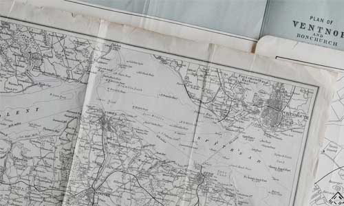
Hear what our clients have to say about our digitisation services
TownsWeb Archiving have proved very able and extremely helpful in supporting us to bring a local heritage alive for local people. We would certainly recommend TownsWeb Archiving to other libraries, museums and archives.
Exhibition and Display Officer
We are delighted with the results. Without TownsWeb Archiving’s services we could not have completed the work in time and on budget. Their staff have been nothing but approachable, helpful and attentive and I can strongly recommend their services.
Head of Digital
TownsWeb offered us a complete end-to-end service, from scanning and transcription, to web design and content management software. Their work was completed quickly and to a high standard, and we are extremely pleased with the results.
Information & Archives Officer
Digitisation Frequently Asked Questions
We use bespoke, large format, high-resolution planetary scanners and a range of high-resolution cameras, offering non-contact capture of your precious maps, plans and posters. Our equipment can capture single page or double-page spreads creating output formats in TIFF, JPEG (JPEG2000), PDF (PDFA) or any other industry-standard image format you may require. We can also create further surrogate files, such as OCR’d multi-page PDFs, MS Word and eBooks.
All files are captured by our highly trained digitisation technicians using overhead, daylight balanced, non-heat producing lighting, before undergoing a formal quality assurance checking procedure. The final step in the process is the delivery of your electronic files by hard drive.
As standard, TWA survey all material prior to any digitisation project being carried out to ensure that it can withstand the scanning process. If there is evidence of fragility, brittleness, and/or mould, or any other signs of damage to yout maps, plans or posters, then recommendations will be made for how to repair and stabilise the content appropriately.
There are many things that need to be taken into consideration when costing your digitisation project, such as:
- Fragility
- Scale of the collection
- The size of indivdual items
- Any cleaning processes
- Whether items are contained in sleeves
Consequently, it’s impossible to give a definitive answer as to cost, but you can get a rough estimate using our digitisation quote calculator below.
Maps, plans and posters are often largescale items and, as such, they are more prone to damage and tearing. They are also often stored rolled, which means they must follow a relaxation process to ensure they lay flat before capture. They can sometimes be so large that they have to be digitised in parts before being digitally stitched back together again. If any of these steps are not taken then this could impact overall image quality, with a loss to the rich detail contained within, as well as any plans to carry out Optical Character Recognition (OCR) in the future.
Calculate the cost of digitising your loose items collections
Simply input your specifications into the FREE digitisation quote calculator below, to get an estimate of how much your project might cost. The prices quoted are indicative for your material quantity and type but are subject to any additional costs such as file naming, folder naming and any post-processing requirements you may have.
If you don’t see your specific material listed it might be that your content is more suited to an informal chat.
Calculate your project costs
Enter your project details, material type and email using the form provided

Review your quote
Look out for your free no obligation quote, received straight to your inbox

Speak with our consultants
Book a discovery call if you have any questions or wish to proceed with your project
Loose Item Digitisation Quote Calculator
Important Note: We charge a standard £500 project set-up and management fee in addition to the cost of digitisation.
Capture the data within your Maps, Plans & Posters
Digitisation places your maps, plans & posters in the perfect format to capture the valuable data contained within them, offering great potential for system integration and online access and discovery.
Capture the data within your collection with handwritten transcription, identifying any handwritten or cursive script within images and converting this to searchable and machine readable textual metadata through a process of scanning. Using bespoke transcription validation software we can guarantee highly accurate results, carrying out any preprocessing measures required and outputting to any format.
Learn more about Handwritten Transcription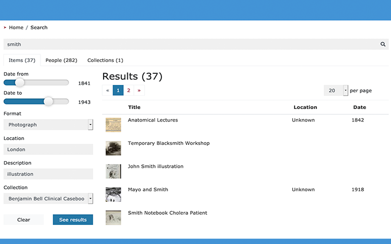
Publish your Maps, Plans & Posters online
PastView is the perfect platform for publishing your maps, plans & posters online, offering great potential for access and discovery. Manage and publish your collection with:
- Advanced Search: Creating numerous deep dive opportunities into your collections
- High Resolution Zoom: Revealing every minute detail through large scale manipulation
- Print Facilities: Creating sources of revenue through the sale of glossy physical prints
- Watermarking Security: Safeguarding and protecting your images from copyright infringement